West coast road trip routes: choose your style
There’s no single “west coast road trip.” The coast stretches over 1,300 miles from the Canadian border down to the Mexican line, with mountains, deserts, cities, and tiny coastal towns all offering different experiences. Rather than trying to do everything in one trip—which tends to leave people exhausted and broke—it helps to pick a route that matches your available time and what you actually want to see.

The coastal core: San Francisco to Los Angeles (5–7 days)
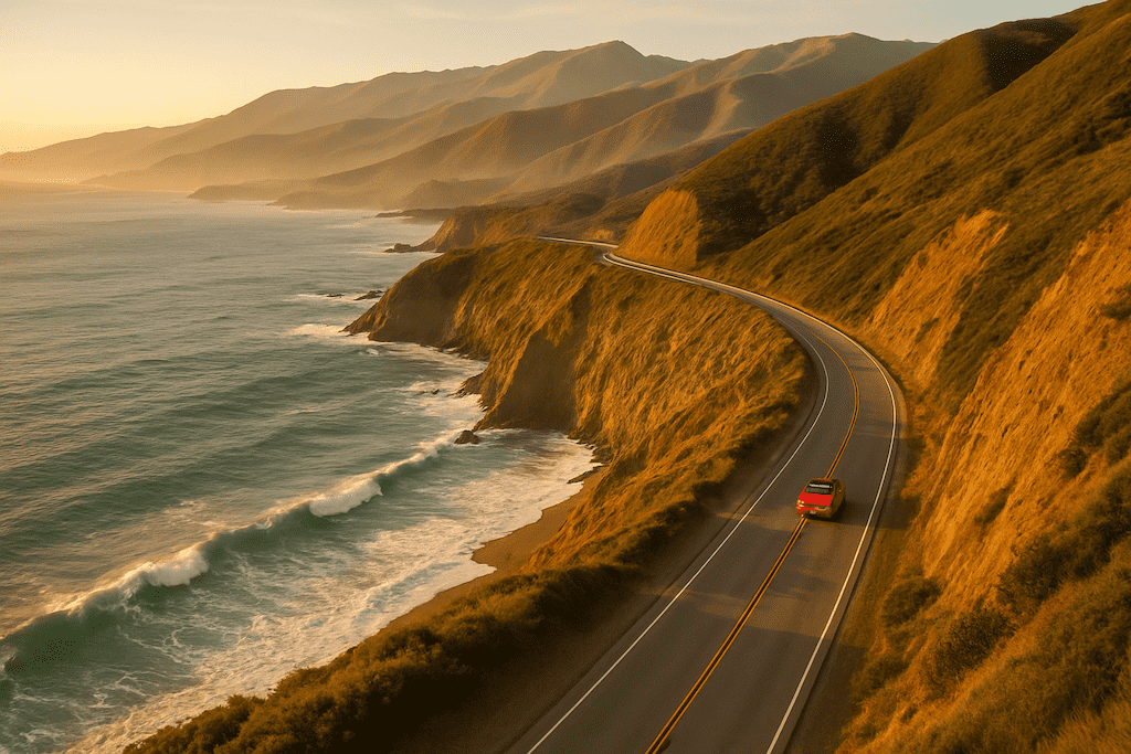
This is probably what you picture when someone says “west coast road trip.” You’re on Highway 1 most of the way, with the Pacific on one side and redwoods, cliffs, or mountains on the other. It’s compact enough to fit into a long weekend (though honestly, a week is better), and it hits the icons: the Golden Gate Bridge, Monterey’s Cannery Row, Big Sur’s dramatic coastline, Hearst Castle, Santa Barbara’s coastal charm, and the energy of Southern California beach towns.
The daily rhythm feels manageable. You’re never more than 3–4 hours from your next stop, which means you can linger over morning coffee, take detours to tide pools or hiking trails, and still arrive at your evening destination before sunset. The driving is scenic but winding—Big Sur especially demands your full attention—so factor in time for the curves and pullouts.
One important note: this route is heavily shaped by Highway 1 closures and Big Sur detours. As of late 2025, a 6.8-mile section between Esalen and Lucia has been closed due to landslide repairs, with Caltrans targeting a March 2026 reopening if weather permits. That means some of the most dramatic Big Sur scenery is currently inaccessible. You’ll detour inland via US-101 and CA-46 through Paso Robles, which adds an hour to your drive but honestly isn’t a deal-breaker—you still get stunning coastline north and south of the closure. Checking the live closure map before you leave is essential.
The full coast: Seattle to San Diego (12–16 days)
If you have two weeks and want to see how the West Coast actually varies from region to region, this is the route. You start in the Pacific Northwest’s urban energy and misty mountains, work down through old-growth redwoods and the golden California coast, and end in San Diego’s year-round sunshine and laid-back beach culture.
A typical flow looks like: Seattle, then either a detour to Olympic National Park or Mount Rainier (both worth it), the dramatic Oregon coast starting around Cannon Beach and Haystack Rock, south through small harbor towns and the Columbia River Gorge, down to Portland, then into Northern California’s Redwood National and State Parks. From there, you drop into the San Francisco Bay Area—spend a day exploring the city itself if you want—then follow Highway 1 south through Monterey, Carmel, and the Big Sur region (or detour inland if the closure is still in place), Santa Barbara, Los Angeles, and finish in San Diego.
Two weeks feels rushed for this. Sixteen days lets you breathe, spend a night in Portland, skip one or two smaller towns without guilt, and actually process the landscape changes. The route naturally breaks into pairs or clusters—two nights in one place—which keeps the packing and unpacking manageable.
National parks loop: Sierra and coast (10–14 days)
This option blends the mountains with the ocean instead of sticking purely to the coast. You’re hitting Yosemite National Park, Sequoia and Kings Canyon, maybe Death Valley or Joshua Tree, then connecting back to the coast for the final leg. It’s more ambitious in terms of elevation gain and driving distances, but if you love granite peaks, alpine lakes, and wildflower meadows as much as ocean views, it’s worth considering.
The main constraint here is Yosemite 2025 reservations and entry requirements. Peak-hours timed-entry reservations are required from June 15 through August 15, 2025 (6 a.m. to 2 p.m. daily), plus Memorial Day and Labor Day weekends. Each reservation costs $2, and they sell out almost instantly when they open on May 6. You can still enter before 6 a.m. or after 2 p.m. without a reservation, but you’ll pay the $35 vehicle entrance fee either way. Visiting in shoulder seasons—late May, early June, or September—often feels less crowded and gives you more flexibility on timing.
Live conditions, closures, and how to adjust
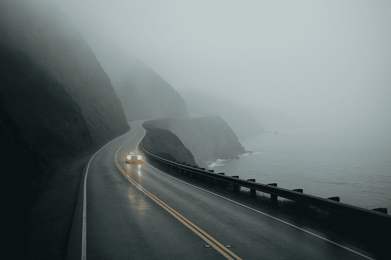
Here’s where planning meets reality. The West Coast is beautiful partly because it’s steep, dramatic, and geologically active. That same geology means roads close. Fog rolls in thick enough to reduce visibility to 20 feet. Occasional weather brings landslides. Rather than pretending these things won’t happen, it’s better to know what to do when they do.

Highway 1 through Big Sur: current status and your options
Big Sur is the crown jewel of the west coast road trip, and also the part most likely to surprise you with a closure. The rocky terrain and steep cliffs that make it so visually stunning are the same features that make it unstable. Heavy rain or erosion can shift a segment from open to closed in days.
As of November 2025, the major closure is the 6.8-mile stretch between the Esalen Institute and Lucia (closed since February 2024). Caltrans is doing slope stabilization work and estimates it will reopen by March 2026, weather permitting. Over 100 miles of Highway 1 remain open—the northern sections from Carmel down to Ragged Point are accessible, as are the southern sections from San Simeon south to Cambria.
If the closure is still active during your trip, you have two options: skip this section and explore the open ends separately (which honestly, many people do—the northern Big Sur has some of the most iconic bridges and pullouts, and the southern section has a quieter, more isolated charm), or take the inland detour. US-101 through Paso Robles adds roughly 45 minutes to an hour to your travel time, but it’s a pleasant drive and you can pop back out to the coast further south. Many travelers do both in different trips—that’s actually encouraged.
The lesson: don’t let a closure ruin your trip. Adjust, explore what’s open, and often you’ll find something unexpected.
Fog, weather, and the best times to drive
The Pacific Coast isn’t moody exactly, but it has patterns. Summer (June–August) brings marine layer fog, especially in the mornings and along the central California coast. This fog can block views, make photography tricky, and slow driving speeds on curves. It usually burns off by midday or early afternoon, but if you’re chasing that golden-hour light at Point Lobos or Bixby Bridge, an early morning fog might mean moving to your backup plan.
Late spring (May–early June) and early fall (September–October) tend to offer clearer skies and fewer crowds. Winter brings storms and higher landslide risk, which is why so many roads close then. It’s not impossible to drive the west coast in winter—just more unpredictable.
Distance, drive times, and pacing that feels real
The temptation is to cram. You see all these beautiful stops on Instagram and want to hit them all. But a west coast road trip where you’re constantly rushing to the next pullout stops being fun pretty quickly.
Here’s a rough breakdown of major legs on the San Francisco to Los Angeles coastal route:
- San Francisco to Monterey: 2.5–3 hours (120 miles)
- Monterey to Carmel/Big Sur (northern sections): 2–3 hours (50–70 miles)
- San Simeon (Hearst Castle region) to San Luis Obispo: 1.5–2 hours (60 miles)
- San Luis Obispo to Santa Barbara: 3–4 hours (150 miles)
- Santa Barbara to Los Angeles: 2–2.5 hours (100 miles)
Those times assume relatively straight driving. Add 30–60 minutes if you’re stopping frequently for photos, hiking short trails, or grabbing lunch. Some days you might drive only 2 hours total and spend the afternoon exploring. Other days you might cover 5 hours to position yourself for a specific overnight location. Both are fine—there’s no “correct” pace, just the pace that works for your group.
Budget, passes, and realistic costs
A west coast road trip ranges wildly in cost depending on where you stay and how you eat. Here’s an honest breakdown:
Gas: Assume 25–30 mph on coastal roads. A typical 500-mile route burns $60–$90 in fuel at current prices (assuming 25 mpg). The coastal route from SF to LA is roughly 400–450 miles depending on detours, so budget $50–$75. If you’re doing the full Seattle to San Diego route (800+ miles), expect $120–$180.
National park fees: Most parks charge $30–$35 per vehicle for a week-long pass. The America the Beautiful annual pass costs $80 and covers all federal parks for a year—if you’re hitting Yosemite, Death Valley, Joshua Tree, and any others, it pays for itself quickly.
Lodging: This is where trips really vary. Budget motels in small coastal towns run $80–$120 per night. Midrange hotels (the kind with decent reviews and a hot breakfast) are $120–$180. Splurge hotels in Big Sur, Carmel, or Santa Barbara can easily hit $250+. Camping is usually $20–$40 per night for a basic site, sometimes more for oceanview spots. A reasonable mix for a two-week trip might average $140 per night, or roughly $2,000 total.
Food: Casual dinners run $15–$25 per person, sit-down restaurants $30–$50+. Breakfast and lunch might be $10–$20 if you’re mixing cafés and casual spots. Budget $40–$60 per person per day for food if you’re doing a mix of prepared meals and casual eats, and more if you’re dining well every night.
Pulling it together: A mid-range 7-day coastal trip from SF to LA might cost $2,500–$3,500 for two people (fuel, lodging, food, park fees), or roughly $1,250–$1,750 per person. A full two-week Seattle to San Diego trip on a similar budget would be $4,500–$6,500 total. Going cheaper is possible (camping, more grocery store meals); going luxe quickly doubles that.
Electric vehicles and charging along the coast
More people are asking: “Can I drive the west coast in an EV?” The answer is yes, but with planning. The main corridors—I-5, US-101, and Highway 1—have developed charging networks, though density varies significantly.
Northern California (SF north) has decent coverage. Central California’s Big Sur region has fewer options, and the stretch between San Luis Obispo and Santa Barbara is a bit sparse. Southern California is solid. Oregon and Washington have growing networks, though some rural stretches still require planning.
Generally, you’ll want to charge at your overnight location when possible. DC fast charging can add 200+ miles in 20–30 minutes, but relying on it for every leg gets tedious. The west coast EV charging guide has specific recommendations for corridor planning and charger density by region, plus checklists for different vehicle ranges.
If you’re driving a gas car, stick to major towns for fuel. Don’t let your tank drop below a quarter full on remote stretches.
Lodging strategy: where to base yourself
Instead of moving every single night, consider staying in one or two spots and day-tripping from there. This reduces packing fatigue and lets you actually get to know a place.
Northern California hub: San Francisco is obvious, but if you want coast-focused exploration, Monterey is excellent. It’s close to Cannery Row, Point Lobos, Big Sur access (north end), 17-Mile Drive, and the Santa Cruz Mountains. Hotels range from $120–$180 off-peak.
Central Coast hub: San Luis Obispo or Santa Barbara work well. SLO is more casual and affordable; Santa Barbara is gorgeous but pricier ($150–$200+). Both are good bases for exploring the Big Sur region or pushing south to LA.
Pacific Northwest: Seattle for a city experience, or base in a small Oregon Coast town like Cannon Beach or Newport if you want quieter beach time. Prices are reasonable ($80–$130 for decent motels).
The advantage of this approach: you wake up in the same bed, leave your “home base” stuff, and explore fresh. You’re not managing luggage every day. You have time to actually walk around neighborhoods instead of just passing through.
When to go: seasonality and what changes
The best time for a west coast road trip depends on what you’re willing to tolerate.
April–May (Spring): Weather is warming, wildflowers are often blooming, and crowds are moderate. Fog is starting to roll in more frequently by May. Good balance of sunshine and fewer tourists than summer.
June–August (Summer): Peak season. Warmest weather, but also fog along the central coast, highest prices, and the most crowded parks. Yosemite requires peak-hours reservations from June 15–August 15 if you’re heading into the Sierra. Aim for early June or late August to soften the crowds a bit.
September–October (Fall): Often called the “best” time—the weather is stable, fog is lighter, summer crowds have gone home, and prices drop. Water is still swimmable for brave souls. September is reliably good; October is a coin flip (can be perfect, can have early storms).
November–March (Winter): Fewer tourists, lowest prices, moody lighting for photography. But closures are more common, weather is unpredictable, and some mountain passes might need chains. Not impossible, just requires more flexibility.
Packing and safety: what you actually need
The coast changes weather rapidly. Bring layers. Mornings can be cold and foggy; afternoons warm up. Evenings cool down again. A light fleece, long pants, and a water-resistant jacket cover 80% of situations.
For driving safety on Highway 1, especially through Big Sur: watch your speed on curves, use pullouts to let faster cars pass, and don’t stop on the highway except in emergencies. Fog can roll in suddenly, so keep headlights on low beam and leave extra distance between you and the car ahead. If fog gets really thick, it’s completely reasonable to pull over at a safe spot and wait 20 minutes for it to clear.
Sneaker waves are real at certain beaches. Don’t turn your back to the ocean at rocky points, and watch for warning signs about tide timing. Wet rocks are slippery. Wear shoes with good grip if you’re exploring tide pools.
Cell service is spotty on remote stretches. Download offline maps just in case. A physical map isn’t old-fashioned—it’s practical backup.
Sample itineraries: three approaches
Six-day coastal sprint: San Francisco to Los Angeles
Day 1: Arrive in San Francisco. Golden Gate Bridge walk, Marin Headlands overlook, dinner in the Mission or Marina. Stay in SF.
Day 2: Drive south through Half Moon Bay, Santa Cruz (boardwalk, surf beaches), down to Monterey. Cannery Row, Point Lobos. Stay Monterey or Carmel.
Day 3: Bixby Bridge, McWay Falls (if accessible), Point Lobos hiking, Big Sur coastal drives. If the Esalen–Lucia closure is active, explore the northern Big Sur sections thoroughly. Stay in Big Sur, San Simeon, or SLO.
Day 4: Hearst Castle tour or drive past it, elephant seal colonies at Año Nuevo, San Luis Obispo wine country if time allows. Stay SLO.
Day 5: Drive south to Santa Barbara (2.5–3 hours), explore the Mission, Stearns Wharf, wine tasting. Stay Santa Barbara.
Day 6: Malibu beaches, sunset at Malibu Pier or Point Dume, drive to Los Angeles. Explore Venice or Santa Monica in the evening or plan this as a partial day and arrive with the afternoon ahead of you.
Two-week full coast: Seattle to San Diego
Days 1–2: Seattle. Pike Place Market, waterfront, Olympic Mountains views. Base day to explore the city without rushing.
Days 3–4: Either Olympic National Park or Mount Rainier detour (full day each), or skip for more coast time. Come back to the coast at Cannon Beach, Oregon. Explore Haystack Rock and the dramatic northern Oregon coast.
Days 5–6: Columbia River Gorge, Portland breweries, small harbor towns like Newport or Yachats. South Oregon coast (Bandon, Coos Bay area if time allows).
Days 7–8: Redwood National and State Parks. Drive among the old-growth giants, Newton B. Drury Scenic Parkway, Trinidad Beach. Stay in Eureka or Fortuna.
Days 9–10: San Francisco. Explore neighborhoods, day-trip to Big Sur or Point Reyes (choose one).
Days 11–12: Monterey, Carmel, Big Sur coast or detour as needed. Two nights to actually sit with the landscape.
Days 13–14: South toward Santa Barbara and Los Angeles, or if you want to slow down, stay another night on the central coast and compress the final leg.
Day 15+: San Diego area (La Jolla Cove, Balboa Park, beaches), or optional: backtrack into the mountains for Anza-Borrego or Joshua Tree before heading home.
12-day mountain and coast loop
Days 1–2: San Francisco base or drive south. Settle near San Jose or Monterey.
Days 3–5: Yosemite National Park. Enter before 6 a.m. to avoid peak-hour crowds if reservations are required. Day hikes: Half Dome viewpoint (easy), Vernal Fall, Mirror Lake trail. Sunrise at Glacier Point or Tunnel View.
Days 6–7: Sequoia and Kings Canyon National Parks. Drive through Giant Forest, hike the Congress Trail, explore Moro Rock. Kings Canyon road is often closed in winter, so timing matters.
Day 8: Drive day: Head to the coast via US-101 and the Big Sur region. Coastal restoration time.
Days 9–10: Big Sur, Carmel, Point Lobos, Monterey. Coast-focused recovery from mountain driving.
Days 11–12: Santa Barbara, Los Angeles area, or drive home from Monterey.
Frequently asked questions
What’s the best direction to drive Highway 1—north or south? Both work. Southbound (SF to LA) gives you the ocean on your left and easier beach stops; northbound has the ocean on your right. Southbound is traditional, northbound feels fresher if you’ve driven it before. Choose based on where you’re flying in.
Can I drive the west coast in winter? Yes, but weather is unpredictable. Closures happen. But you’ll see fewer tourists, prices drop, and the landscape has a moody beauty. If you’re flexible on dates, it’s doable. If you have fixed dates, spring or fall are safer.
How many days do I really need? Five days is the bare minimum to feel like you did something (SF to LA with stops). A week is comfortable. Two weeks lets you breathe. Longer trips add depth—you can backtrack, linger, take detours that aren’t on the original plan.
Should I rent an RV or car? RVs give you flexibility but are harder to park in small towns and use more fuel. A regular car (ideally with decent fuel economy) is easier for navigating coastal towns and hiking trails. If you’re camping, a truck or SUV that fits gear works well. Most trips work fine in a normal sedan or compact SUV.
What if Highway 1 is closed? You detour inland on US-101, CA-46, or I-5. It adds time, but the rest of the coast is still accessible. Some of the best discoveries happen when you’re forced off the main route.
Final thoughts on your west coast road trip
The west coast offers one of the most rewarding road trips in North America, but only if you let go of the idea that it needs to be perfect. Weather will be different than the forecast. A stop you planned to skip will turn out to be your favorite. You’ll spend more at breakfast than you budgeted. The sunset at Point Lobos won’t have the light you imagined. You’ll drive through fog for three hours. And somewhere in that imperfection, you’ll have moments that actually stick with you—the kind of travel memories that matter.
Start with a route that makes sense for your timeline. Check the live road conditions before you leave (especially for Highway 1 closures and any seasonal impacts). Pack layers and give yourself permission to be flexible. Don’t rush the beautiful parts. Take the detours that interest you, even if they’re not on the original plan. And remember: a great west coast road trip isn’t about checking boxes. It’s about spending time on a remarkable stretch of coast and letting it change how you see the landscape—and sometimes, yourself.
No Comment